Monday, September 12, 2022

Struve Geodetic Arc

Finland, Norway, Russia, Ukraine, Maldova, Estonia, Belarus, Sweden, Latvia, Lithuania 
Missing:  Latvia, Lithuania
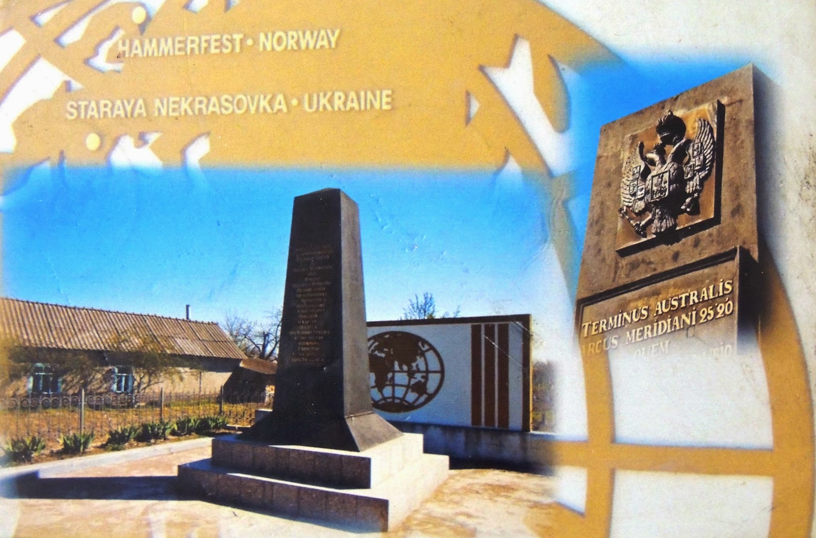
The Struve Arc is a chain of survey triangulations stretching from Hammerfest in Norway to the Black Sea, through 10 countries and over 2,820 km. These are points of a survey, carried out between 1816 and 1855 by the astronomer Friedrich Georg Wilhelm Struve, which represented the first accurate measuring of a long segment of a meridian. This helped to establish the exact size and shape of the planet and marked an important step in the development of earth sciences and topographic mapping. It is an extraordinary example of scientific collaboration among scientists from different countries, and of collaboration between monarchs for a scientific cause. The original arc consisted of 258 main triangles with 265 main station points. The listed site includes 34 of the original station points, with different markings, i.e. a drilled hole in rock, iron cross, cairns, or built obelisks. Source whc.unesco.org

Moldova: Rudi Village

Thanks to Mr Tiago for send this this card from Portugal.

Estonia: Tartu Observatory


Thanks to Mr Patrik.
Norway: Hammerfest

Thanks to Jo Heggland.
Finland: Oravivuori

Thanks to Ms Sini
Finland: Alatornion Kirkko Church

Thanks to Ms Sini
Russia: Gogland Island

Thanks to Mr Vadim
Ukraine: Staraya Nekrasovka

Thanks to Ms Olesya
Belarus: Ossownitza

Thanks to Ms Katya
Belarus: Various Points

Thanks to Ms Lisa.
Sweden: Perra Vaara, Haparanda

Thanks to Ms Merja Deb. Bottom row (L-R) third box is Struve Geodetic Arc.

Tuesday, July 5, 2022

United Kingdom/ Germany: Frontiers of the Roman Empire

The ‘Roman Limes’ represents the border line of the Roman Empire at its greatest extent in the 2nd century AD. It stretched over 5,000 km from the Atlantic coast of northern Britain, through Europe to the Black Sea, and from there to the Red Sea and across North Africa to the Atlantic coast. The remains of the Limes today consist of vestiges of built walls, ditches, forts, fortresses, watchtowers and civilian settlements. Certain elements of the line have been excavated, some reconstructed and a few destroyed. The two sections of the Limes in Germany cover a length of 550 km from the north-west of the country to the Danube in the south-east. The 118-km-long Hadrian’s Wall (UK) was built on the orders of the Emperor Hadrian c. AD 122 at the northernmost limits of the Roman province of Britannia. It is a striking example of the organization of a military zone and illustrates the defensive techniques and geopolitical strategies of ancient Rome. The Antonine Wall, a 60-km long fortification in Scotland was started by Emperor Antonius Pius in 142 AD as a defense against the “barbarians” of the north. It constitutes the northwestern-most portion of the Roman Limes. Source: whc.unesco.org
Inscribed: 1987 Ext: 2005,2008

Postcard 1: Hardins Wall, UK
Thanks to Mr Smith
Postcard 2: Saalburg, Germany

Thanks to Marlo.
Postcard 3: Saalburg, Germany

Thanks to Ms Ana.

Germany: Wartburg Castle

Wartburg Castle blends superbly into its forest surroundings and is in many ways 'the ideal castle'. Although it has retained some original sections from the feudal period, the form it acquired during the 19th-century reconstitution gives a good idea of what this fortress might have been at the height of its military and seigneurial power. It was during his exile at Wartburg Castle that Martin Luther translated the New Testament into German. Source: whc.unesco.org
Inscribed: 1999

Postcard 1: Castle

Thanks to Daj.
Postcard 2: Multiview

Thanks to Ms Annett.
Postcard 3: Inside View

Thanks to Ms Sylvia

United Kingdom/ Germany: The Great Spa Towns of Europe

This transnational property comprises 11 towns, located in seven European countries: Baden bei Wien (Austria); Spa (Belgium); Františkovy Lázně (Czechia); Karlovy Vary (Czechia); Mariánské Lázně (Czechia); Vichy (France); Bad Ems (Germany); Baden-Baden (Germany); Bad Kissingen (Germany); Montecatini Terme (Italy); and City of Bath (United Kingdom). All of these towns developed around natural mineral water springs. They bear witness to the international European spa culture that developed from the early 18th century to the 1930s, leading to the emergence of grand international resorts that impacted urban typology around ensembles of spa buildings such as the kurhaus and kursaal (buildings and rooms dedicated to therapy), pump rooms, drinking halls, colonnades and galleries designed to harness the natural mineral water resources and to allow their practical use for bathing and drinking. Related facilities include gardens, assembly rooms, casinos, theatres, hotels and villas, as well as spa-specific support infrastructure. These ensembles are all integrated into an overall urban context that includes a carefully managed recreational and therapeutic environment in a picturesque landscape. Together, these sites embody the significant interchange of human values and developments in medicine, science and balneology. source:whc.unesco.org
Inscribed: 2021
Postcard 1: United Kingdom (The city of Bath)

Thanks to Ms Nat.
Postcard 2: Germany (Bad Kissingen)


Thanks to Ms Svenja

United Kingdom: New Lanark

New Lanark is a small 18th- century village set in a sublime Scottish landscape where the philanthropist and Utopian idealist Robert Owen moulded a model industrial community in the early 19th century. The imposing cotton mill buildings, the spacious and well-designed workers' housing, and the dignified educational institute and school still testify to Owen's humanism. Source: whc.unesco.org
Inscribed: 2001

Postcard 1

Thanks to Ms Stella
Postcard 2

Thanks to Mr George.

Portugal: Historic Centre of Guimarães

The historic town of Guimarães is associated with the emergence of the Portuguese national identity in the 12th century. An exceptionally well-preserved and authentic example of the evolution of a medieval settlement into a modern town, its rich building typology exemplifies the specific development of Portuguese architecture from the 15th to 19th century through the consistent use of traditional building materials and techniques. Source: whc.unesco.org
Inscribed: 2001

Postcard 1


Thanks to Mr Ogait.
Postcard 2

Thanks to Ms Martha.

France: Cordouan Lighthouse

The Lighthouse of Cordouan rises up on a shallow rocky plateau in the Atlantic Ocean at the mouth of the Gironde estuary in the Nouvelle-Aquitaine region, in a highly exposed and hostile environment. Built in white limestone dressed blocks at the turn of the 16th and 17th centuries, it was designed by engineer Louis de Foix and remodelled by engineer Joseph Teulère in the late 18th century. A masterpiece of maritime signalling, Cordouan’s monumental tower is decorated with pilasters, columns modillions and gargoyles. It embodies the great stages of the architectural and technological history of lighthouses and was built with the ambition of continuing the tradition of famous beacons of antiquity, illustrating the art of building lighthouses in a period of renewed navigation, when beacons played an important role as territorial markers and as instruments of safety. Finally, the increase of its height, in the late 18th century, and the changes to its light chamber, attest to the progress of science and technology of the period. Its architectural forms drew inspiration from ancient models, Renaissance Mannerism and the specific architectural language of France’s engineering school École des Ponts et Chaussées. Source:whc.unesco.org
Inscribed: 2021


Thanks to Maud

Wednesday, June 29, 2022

Belgium: The Four Lifts on the Canal du Centre and their Environs, La Louvière and Le Roeulx (Hainault)

The four hydraulic boat-lifts on this short stretch of the historic Canal du Centre are industrial monuments of the highest quality. Together with the canal itself and its associated structures, they constitute a remarkably well-preserved and complete example of a late-19th-century industrial landscape. Of the eight hydraulic boat-lifts built at the end of the 19th and beginning of the 20th century, the only ones in the world which still exist in their original working condition are these four lifts on the Canal du Centre. source:whc.unesco.org
Inscribed: 1998

1.Houdeng-Goegnies- Received
2.Houdeng-Aimeries
3.Strépy-Bracquegnies- Received
4.Thieu- Received

Postcard 1: Strépy-Bracquegnies

Thanks to Ms Tani
Postcard 2: Houdeng-Goegnies


Thanks to Dager
Postcard 3: Upstream view of Strépy-Thieu Ascenseur

Thanks to Giles for the extra long card.

Netherlands/ Belgium: Colonies of Benevolence

The transnational serial property encompasses four settlements; cultural landscapes with one colony in Belgium and three in The Netherlands. Together they bear witness to a 19th century experiment in social reform, an effort to alleviate urban poverty by establishing agricultural colonies in remote locations. Established in 1818, Frederiksoord (the Netherlands) is the earliest of these colonies and home to the original headquarters of the Society of Benevolence, an association which aimed to reduce poverty at the national level. Other components of the property are the colonies of Wilhelminaoord and Veenhuizen, in the Netherlands, and Wortel in Belgium. As the colonies’ small farms yielded insufficient revenues, the Society of Benevolence sought other sources of revenue, contracting with the State to settle orphans, soon followed by beggars and vagrants, leading to the creation of “unfree” colonies, such as Veenhuizen, with large dormitory type structures and larger centralized farms for them to work under the supervision of guards. The colonies were designed as panoptic settlements along orthogonal lines. They feature residential buildings, farm houses, churches and other communal facilities. At their peak in the mid-19th century, over 11,000 people lived in such colonies in the Netherlands. In Belgium their number peaked at 6,000 in 1910. Source:whc.unesco.org
Inscribed: 2021
Postcard 1

Thanks to Mr Javier who is visiting Netherlands.

Postcard 2


Thanks to Billie.